Background and Project Objectives
The projects objective is to develop a service that estimates Gross Primary Productivity (GPP) and Net Primary Productivity (NPP) as indicators for stored Carbon in vegetation based on the Light Use Efficiency (LUE) model using remote-sensing imagery. We hereby make use of the relationship between GPP and NPP and carbon storage based on the principle of photosynthesis.
The model results will be incorporated in a user-friendly interface in the form of maps, graphs and other visualization and information tool, providing clear and easily interpretable representation of the carbon storage within a study area.
The aim is to increase transparency, awareness and provide information on past and present carbon storage in the context of greenhouse gas emissions and climate change.
The service is intended to support the implementation of sustainable management strategies and facilitate the monitoring and certification processes of carbon offset projects. By providing a cost-effective, reliable and transparent carbon storage monitoring tool based on remote sensing data, we aim to support and simplify the monitoring of CO2 storage globally and for different spatial and temporal resolutions.
Service/System concept
The service provides insights on carbon storage in vegetation based on remote-sensing-based Light Use Efficiency (LUE) model and presents the results in a map-based user-interface.
The user-interface allows access for several user group roles and that have different analysis and output feature options. Apart from carbon balance for a predefined study area, additional analysis options may include comparison and plant health analysis.
The results are displayed as multifunctional maps, graphs and charts and can be downloaded or embedded in a client's website, depending on the chosen subscription plan.
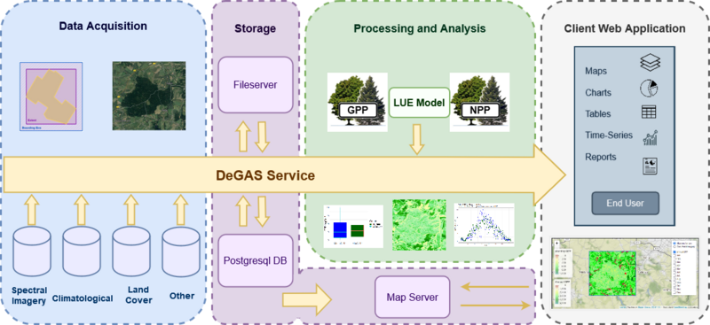
The system architecture consists of four major subsystems, namely data acquisition, storage, Processing and analysis and client web application. The data Acquisition module is comprised of two main components, the acquisition of Earth Observation imagery and the acquisition of further relevant vector data or tables. After data cleansing the relevant files will be passed to the Storage module. Within the Storage module, vector data and tables will be stored within a PostgreSQL/PostGIS database and raster files will be stored at the file server. The Processing and Analysis module is comprised of 4 main sub-modules: the pre-processing, processing, analysis, and validation. Following the processing, the analysis sub-module entails the calculation of carbon balance. The results will be stored within the storage module for further analysis and visualization within the Client Web Application.
Current status
In the scope of the ESA Kick-Start project DELPHI IMM defined the user and customer segments, evaluated the economic feasibility and conducted a test analysis for the Tharandt forest area in Saxony, Germany.
The FLUXnet GPP measurements of the Tharandt station for year 2014 served as validation dataset. The test model provides reasonable GPP estimates with a correlation coefficient of 0.83. The resulting annual GPP layer
can be seen in figure 4 and in the map below, which additionally shows monthly GPP.
In the next months we are planning on evaluating the model for further test sides with different forest types and biomes to gain information on the global applicability.
Users and their needs

- Providers like landowners or agribusinesses using sustainable management practices or looking to provide areas for carbon offsetting,

- Project developers and carbon offset certification entities, that want to monitor the progress of the project and are looking for support within the offset certification process and

- Purchasers like NGOs, governmental entities, companies and individuals, that buy carbon offset certificate to subset their own emissions.

Space assets used:
- ERA5-Land hourly data from 1981 to present. Copernicus Climate Change Service (C3S) Climate Data Store (CDS)
- USGS NASA Landsat 5-9
- Copernicus Sentinel 2
- Copernicus Global Land Cover Layers-Collection 2
One major advantage is the global coverage and applicability, which allows for continuous monitoring with large spatial and temporal coverage. Additionally, using remote sensing data reduces costs compared to ground-measurement-based approaches.
Test Area Tharandt Forest

 for the year 2014")